
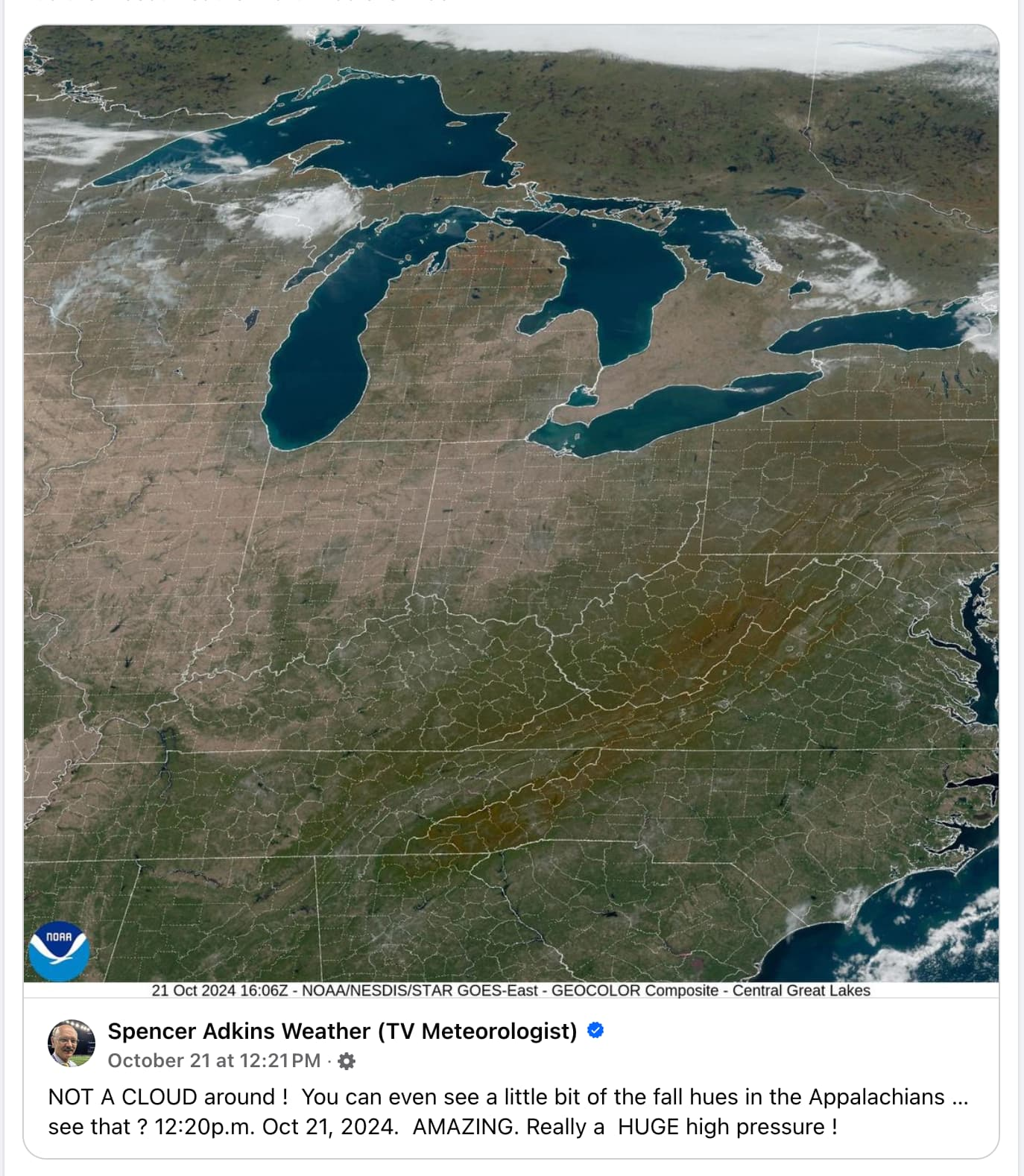
Whoa I didn’t know you could see state and county lines from space. I guess maps are more realistic than I thought!
Imagine how much work it must be to chalk those lines every time it rains.
Bro this ain’t the 1800s, we’re obviously using LED light strips for that now. The downside is that a single section goes dark and we lose mapping data for the entire northeast. Totally worth it though when they turn on the strobe effect.
I’m no weatherologist, but I think those may just be temporary.
What does weatherology have to do with landology? Educate yourself
Do I look like someone who went to university college to you?
If I knew what those words meant, I’d probably be offended
If only I could read
There’s some fanfiction out there that can make you regret learning language at all.
You could probably handle lots of different subjects, Squidster
I can definitely identify wood. I just woke up.
Those lines, too. Did they pick where the states and burrough were based on those white lines?
No, I’m pretty sure it’s like a baseball game. Some dude runs out there every so often and chalks the boundaries a mile or so in width so you can see them from space
Gotta hate when a flood happens and all of a sudden Florida and Georgia become one state.
Florgia
Not all heroes wear capes.
No, England didn’t set the borders on their way out, during this incident
This image also illustrates how artificially brown crop land is. I live in the intermountain west and didn’t expect to see that ground color in Illinois, Indiana, and Ohio…
They’ve been in a drought most of the summer. But ya, also the crops have been pretty much all harvested before this picture was taken.
One of the things I definitely do like living in Indiana is all the trees. In L.A., where I lived for a decade, it was mostly palms and conifers, and then Joshua trees further out. And they’re not all that attractive to me in comparison. Our house used to be surrounded by giant oaks that it was built around. Unfortunately we lost some in recent storms and others were too sick to not be a danger. We still have, I think, 5 of them left and a persimmon tree. We also have a playground that we’re going to dismantle and replace with another tree. Something local that grows relatively rapidly. Maybe a pawpaw? Not sure yet. Terre Haute, where I live, is famous for its sycamores (to the point that it’s the ISU sports team is the Sycamores), so that’s an option, but they’re kind of boring trees IMO.
I have a giant oak tree next to my house, perfectly positioned so that my house is in direct sunlight in the morning but completely shaded by the tree from noon onwards, so even when it’s 100°F outside my house doesn’t get above the low 80s. I love that tree - except for right now when I have to rake the fucking yard.
That’s really awesome. Our trees basically stop all but a tiny sliver of sunlight from getting to the house, but it’s still worth it.
That said, it’s better to not rake at all.
Clearly written by someone without much tree cover. If I didn’t clear my leaves, by spring the grass would be gone, replaced with slimy black mold. Bad idea.
That being said my town collects leaves for compost, and I usually use the mulching mower on the last few weeks. Nothing wasted, no pollution, some nutrients put back, and I don’t have to wade through knee deep leaves, or suffer mold allergies in the spring.
Note, decaying leaves tend to be acidic, so check your lawn ph and be prepared to add lime
As I said already, I have a bunch of trees in our yard. We never rake. The grass is fine.
Ya, where I live, trees don’t necessarily grow even along the river or in the mountains. Berry season is great, tho!
Terre Haute sounds great! I live up by Elkhart, and while we have way too much farmland, I can’t deny how great our forests are up here. We have bogs, too, which are just magical ecosystems.
It’s not great at all aside from the trees and a handful of other things.
Or, I guess, if you really like meth.
Also, this place is a very depressed community. About $40,000 a year average household income, so between that and all the meth, the crime rate is also pretty terrible.
That said, I’ve never been to Elkhart, so I don’t know what it’s like.
Indiana has remarkable nature, especially in the central and southern state. Not too far from you is Shades SP, I would strongly recommend you check out the Turkey Backbone. It’s terrifying but amazing. The flora of that region is a remnant of pre-glacial flooding Indiana, and one can find stands of uncommon conifers there like Tsuga canadensis (Eastern hemlock), and some Populus deltoides (cottonwood) specimens that get over 120 ft tall.
That said, Indiana is a terribly, intractibly backwards state with a rotten culture of meathead “conservatism”, Amish fetishism and drug use. My city is rather progressive compared to many neighboring (my old town used to be the Klan capital of the world, and the dragon whatever still lives there), but even with that the quantity of red hats is eyebrow-raising. I’m afraid Indiana will never get out of this hole. It truly is the “south of the north”, as they call it.
Shades? I want everyone in the area to know for sure Shades is the worst state park anywhere and no one should ever, ever go to it. They should leave that beautiful, almost empty state park in its very pristine state because it is a terrible place and everyone should definitely go to the very crowded and nowhere near as beautiful Turkey Run state park and leave Shades to us poor people who are making the ultimate sacrifice of keeping those insanely long lines on the Turkey Run hiking trail slightly less insanely long.
Edit: Ah, it’s been so long since I could post an inside joke from r/Indiana!
deleted by creator
Osceola
It is harvest season and most crops are brown when it’s time to harvest.
Why are the city and county lines present?
Because they’re always there, haven’t you gone to the edge of your county and looked at the lines? My favorites are the ones that run right through man made stuff like streets and farms.
this is how I thought longitude and latitude worked when I was little. The boat captains would just go over it like a bump on the road
I wish the world worked the way we thought it did as kids. It would be so much more interesting.
It can be tough replacing your roof if you’re on one of the lines. They can sue you if the roofers don’t get it right
I messed around with listening and decoding NOAA satellites at home and depending on the satellite they decode with the states outlined like this. It’s a fun hobby that uses one of those digital antennas,some copper wire and some open source programs.
deleted by creator
On the other hand, “no rain” is a banger.
Great now that’ll be stuck in my head all day. I just want someone to say to meeee oh oh oh ooh!
Alllll i can say bee costume bee costume bee costume is that my life is pretty plain bee costume
Would be better without the grid.
What do you mean? Those lines aren’t really there? But they are crucial to electing the president. And the one at the very bottom is important to keep the brown people out. How could they not be real?
In terms of the visual beauty of it, I agree. But the grid does help people familiar with the U.S. orient themselves.
You have those big ass lakes and still need a country grid to orient yourselfes?
Believe it or not, you can’t tell whether you’re in Kentucky or Tennessee by looking at those big-ass lakes, what with them being nowhere near them.
I don’t think you have a real picture of the enormous size of the U.S.
I mean, US is roughly a trapezoid, lakes on top, mountain range left and right side… Anyway, it hinders the purpose of seeing the fall colours.
“Roughly a trapezoid” that averages 1650 miles/2660 km across from north to south.
Edit: I just looked it up, the northernmost point is Angle Inlet, MN. The southernmost point is Key West, FL. Both are on the map. If you drove nonstop from one to the other, it would take you 36 hours.
What’s funny to me is that this is just the North to South axis, so if you want to full on go NW to SE, you can do Cape Flattery, WA to Key West, FL for a 55 hour road trip, assuming you’re on meth and have a fuel tank large enough to do 3650 miles or roughly 5870 km without stopping.
I’m now tempted to take a month off to come visit your country some time in the next few years, enjoying the best of both worlds: My 28 days of basic PTO as an Estonian, and your amazing landscapes in the US.
Of course I’m also worried that if I were to customize the route to include places actually worth visiting, rather than just stopping at gas stations and hotels, a month wouldn’t be close to enough. Just adding the Grand Canyon adds like 8 or 9 extra hours of driving!
I’ve always wanted to take the East/West train route across the U.S. (while it still exists). Start in New York and end in California.
Let’s be honest, most americans can’t point their house out on a map unless it’s googlemaps.
That’s got to make for some nice photos even at ground level.
I agree. You could get some amazing vistas from the top of a cliff or mountain or high hill. It makes me what distance the visibility was.
Reminds me of the Rimworld world view
The great lakes are stunning.
The colours have been exceptionally magnificent this year in Ontario.
Same in Colorado where we usually only get Green and Yellow (aspens). This year red is vibrant. I miss that having grown up in Virginia with its gorgeous fall colors.
They’re always beautiful here in Indiana, but they sure seem more vibrant this year.
I just hope that’s not some sign of something bad. It seems like every time something seems good like this it’s because of climate change or something.
well, just get the sun in your eyes now and you may be surprised to find it’s not a dream.
I can see my house!
How many of y’all are tracking counties lived in?
I got 2 on my bingo card, but current is not pictured.
It’s interesting to me how you can tell red states from blue states based on how their counties are divided. Up north is nice, squared, organized. But once you get into Arkansas, Tennessee, West Virginia, the county lines drastically change to a chaotic, gerrymandered mess.
It’s not the politics, its. the geography. The counties that seem chaotic make perfect sense on the ground where the lines follow natural features in the land such as rivers and mountains.
Yeah you can even follow the lines along the Appalachian, the very subject of this post. The blue north east is also very chaotic. The square boxes are mostly the midwest with very featureless flat geography, and those sparse country states tend to trend red.
You do know that voting district lines and County lines aren’t the same thing, right?
I’m afraid it’s not that simple. I’m up north in Indiana. It’s very much a red state. South of us is Kentucky, which is mostly red, but it’s governor is a Democrat. East of us is Ohio, which is sort of a mix, but Republicans mostly control it. West of us is Illinois, which is really only a blue state because of Chicago. Most of the rest of it is red. Finally, north of us is Michigan, which is a blue state but also full of crazy right-wing militias, a group of whom got caught with a plot to kidnap the governor. Not sure if they have been convicted yet.
Hmm… Then maybe I’m full of shit.
I wonder why there’s such a drastic change between those states then. And it seems like there’s a clear line where it falls apart, so I chalked it up to party influence.
Geography, like others have already told you.
It’s like the Midwest where the land is flat and everything was planned out on a map ahead of time, is laid out in a grid.
However anywhere with mountains, meandering rivers, earlier settlement before map planning, is laid out by settlement patterns strongly influenced by natural features
I think it’s a rural vs. urban thing mostly.
I’m surprised no one has brought it up so far. This is from way back when the US was still expanding east to west. Land Ordinance of 1785
It was literally just a means of dividing up the land to make it easier to manage. This is why much of the plains states follow such rectangular county/state lines between water geography.
Edit: States that had their counties/borders established before this act will have more organic geography following boundaries. Counties/States settled after 1785 will display this grid-like pattern.


