Can you drive 120km/h in those areas if you don’t take the train?
I don’t take the train here even though I have one because it takes too long. A 3-4 hr car trip takes all day with the train having to makes its stops.
The closest large city is 50 miles (80km) away. I can be there in 45min to an hour depending on traffic. The train takes almost three hours.
Also, there is no public transportation to get to the train stop which is on the bad side of town and there’s no station to wait inside.
I can go to Paris (500 km) by train in about three hours. That train is musch faster thatn you’d be allowed to drive.
Hungary where you can basically go 140 legally 💀. Now i live in sweden and its 100 most places but the train connections are shit where i live.
thats what you get when you put car and oil billionaires in charge
deleted by creator
From station to station and to Dusseldorf city. Meet Iggy Pop and David Bowie.
It’s funny how you see American movies about the old times and there’s always a train around, but in fact it was the people being around the train.
Actually, every American town founded before 1950 had a train line going through it. Aside from people living on homesteads, and maybe some small antebellum towns, everybody lived in close distance to a train station before they were shut down and torn up.
Worth noting that this map is for passenger rail only. The cargo rail network is much bigger. Basically, this map shows whereever Amtrak runs, where as before the introduction of massively subsidized interstates in the US in 1956, every cargo rail company also ran profitable passenger rail traffic on a massive network that became today’s cargo lines.
The cargo companies dumped their traffic onto the federal government in the 70s and have also ran massive cost cutting programs since, tearing up hundreds of thousands of miles of rail.
https://en.wikipedia.org/wiki/History_of_rail_transportation_in_the_United_States
Another major event in the decline of passenger rail was the elimination of railway post office contracts in 1968 which heavily subsidized passenger transport by also transporting mail
Then the failed merger of the New York Central and the Pennsylvania Railroad(second largest bankruptcy in the country to date, only eclipsed by Enron who simply moved numbers in spreadsheets so do they even count?) created a true crisis as suddenly a significant portion of the eastern US could cease to have rail service
On a related but unrelated note, watching Miles in Transit videos where they take intercity buses, its clear that intercity buses are in danger of ceasing to exist, and he advocates for nationalization. Its hard to imagine such a national bus network as anything but an incredible expansion for Amtrak, greatly improving throughway services and likely improving the quality of bus service. Links here and here(timestamp to the retrospective where he advocates for nationalization)
Who Framed Roger Rabbit was a documentary. Not the toon town stuff. The part about the judge buying the trolley so he could shut it down to build a highway. We used to have a better rail system than anywhere else. Then the car and oil companies bought the tracks and paved over them in the 1920s to 1950s
A perfect example of this is the Boston T. It’s half the size it was 100 years ago and is still considered the 3rd best transportation network in the country, with a full 50% of all daily commutes to Boston happening on the T.
“Who needs a car in LA? We got the best public transportation system in the world!”
Although honestly the feuding between the various tram/rail/bus companies contributed to their demise.
It really is crazy how bad the US rail system is. The last time I was taking a trip of about 1000 miles, I looked into taking amtrak. Not only was it more expensive than driving or flying, but it would take significantly longer as well, at 3 days. I know the train themselves are moving faster, and it’s due to stops, but that’s like 15mh average speed. What year is it?!?
It really is crazy how bad the US rail system is.
It’s also crazy to think that at some point in history, it used to be one of the best in the world. And then it got screwed by oil barons.
That’s not any better in Europe. This is just a random map of some rail tracks. Trying getting from Porto to Rome by train. On this map it would appear as there should be multiple routes. In reality you’ll be lucky to get it done in 3 days.
On google maps its 40h while with car its 24. That means its faster with train because with cars you have to stop to rest so thats 2 or 3 days. At that point airplanes make much more sense.
That’s a 2500km journey across 4 countries, taking about 43h by train including an overnight layover in Madrid.
And most of the journey is beelining it straight toward the destination, from Porto to Madrid, Barcelona, Narbonne, Marseille, Nice, Genova, Rome (plus minor stops along the way).
Flying is more reasonable at that distance (and likely cheaper), but I don’t see how the train network is at fault here.
As far as I know, Amtrak doesn’t own any of its own rails. It leases access from freight hauling railroads. Because of this relationship, the freight lines always prioritize their own trains over Amtrak. So Amtrak will always suffer until this changes.
As bad as it is, when it does work out, it’s way, way better than flying.
Took a trip to Minneapolis on Amtrak from Columbus, WI (closest station to my house in Madison). Everything is so much more low key than air travel. Seats are fairly comfy, and have legroom that might even beat first class air travel. Food is . . . no worse than airlines.
Most of all, I didn’t feel tired at the end of the trip. Air travel always makes me want to spend the rest of the day in bed.
We’d probably go out of Wisconsin Dells next time. It takes the train an hour to go between the Dells and Columbus, and the extra drive time is less than that. But we also found this wonderful pizzeria not far from the station in Columbus, so idk.
If you have the time, Amtrak is a pleasant way to go. You are right about the seats. They are very comfortable and it is nice to walk around on the train and stretch your legs.
My most recent trip on Amtrak was from Effingham IL to Chicago. They only bad part about the trip was the last couple of miles in Chicago. The train stops just a mile or two away from Union Station and we had to wait quite a bit until it was our turn to move into the station.
Edit: I have been corrected by another commenter below. Amtrak owns rails in the NE corridor. Which explains why it operates so much better there.
That’s only like a 4 hr drive though. I drive farther than that for quick overnight trips all the time.
On a train, your holiday starts the moment you board it.
You can watch movies, play board games, even do cartwheels if you so wished. With a view that is constantly changing.
Have you never had sardine cargo class seats on a train? Or standing? I’ve experienced both what you described, and also what I described. Most Americans have never experienced either. One thing about a car though, I can blast my tunes with my subs kicking and not piss off the strangers riding next to me. I’ve had a bunch of nice train trips, but I have had hundreds if not thousands of amazing road trips in a car or on a motorcycle.
It’s way more pleasant than a drive. We also have an EV, and while we can make that range, charging infrastructure isn’t good in northwest Wisconsin, and the Twin Cities are falling behind there, too. Southeast Wisconsin and Chicagoland are much better.
Trains are generally a better environmental option than EVs, anyway, and they can be a more practical option if we fucking try.
Even as it is, I prefer taking the train on this route if possible.
I probably enjoy driving way more than you do, and that’s an understandable difference. But I do spend 90% of my free time where there are no charging stations, which is why I don’t have an EV yet. I also never have to drive in traffic because of where I spend my free time and the fact that I live on the outskirts of town. So driving is pretty pleasant. Honestly, sometimes it’s amazing. I’ve had a couple of great train experiences, but nothing that ever touched a great road trip in a car or on a motorcycle. I think another factor for me is time. I’ve never had more than a week off at once in my life, and I’ve been working for 40 years. When I do have a vacation, I want to get there quickly, enjoy the drive, enjoy the time there, and enjoy the drive back quickly with the music bumping the whole way. I sometimes fly but if it’s under a 24 hr drive away I just drive it straight thru only stopping for fuel. It’s amazing watching the landscape change so much in just one day.
I just don’t have the leave to spend 6 of my leave days simply riding a train or waiting at stations.
Actually, the trains aren’t moving faster. I don’t think there’s a single significant span of passenger rail rated for more than 60mph in the US.
Plus commuter trains get delayed frequently to make way for cargo trains.
That’s because Amtrak only owns their own rails in the NEC (North East Corridor) Boston-NYC-Philly-DC. Everywhere else they are riding on privately owned freight railroad tracks, and the Amtrak trains are often shunted for freight to have priority.
Actually the law states that passenger rail has priority.
It’s just unenforced so freight ignores it
Correct.
Which is illegal, but unenforced
If the government owns the lines, it’s a different story, but most of the rail lines in the US are privately owned. So in most of the US commuter rail is using freight tracks on contract, with one of the stipulations being that the freight trains get priority.
Other way around. Amtrak does have priority on all tracks per the 1973 Amtrak Improvement Act. However, this isn’t enforced, and the rail companies are kicking and screaming to keep it from being enforced.
Interesting. I had heard that many of the rail lines are used under contract because they’re privately owned by the freight companies and that the freight trains having priority was a stipulation of those contracts. Not the lines marked on this map, as those are Amtrak lines, but all the other ones across the country. It might be a local commuter rail thing or something.
NY to DC is solid, it’s the one inter-metro train I’ve taken that’s faster than driving or flying (when accounting for security and travel to/from the airport).
Using it really makes you realize how much better the train system could be. Not even bullet trains, and they’re so much better than cars.
Absolutely agree. It’s so much less frustrating too
Brightline from Orlando to Miami. It’s not fast by international standards but certainly more than 60mph
It’s also super expensive so…
I’m about to board a 12 hour Amtrak ride from Boston to Richmond. It’s a miserable trip (I’ve done it once before) but for two people round trip it cost us $300 less than any flights we could find when we were looking for tickets a month ago.
I was going from ind to den. The cheapest was $600 round trip. A flight is $150-300 and driving would have cost about $450 in gas. Flight and drive would have me arriving the same day.
Northeast coordinator is where Amtrak is at its best. Their coverage of the rest of the country is only barely worthwhile on cost and time.
I’m curious about this map because I definitely live near passenger rail and it’s not showing here.
Non-Amtrak line? I think this is Amtrak specific. There are a few bits of passenger service in the US outside Amtrak, but it wouldn’t add much to this map.
The US map are all Amtrak services and the European map all mainline railways.
I’m more worried about all the lightning bolts Chicago can shoot out to the rest of the country.
Veiny ( ͡° ͜ʖ ͡°)
Iberia needs to keep up, damn it!
They make up for what they don’t have in volume by having crazy cheap and fast trains instead.
They also build them remarkably cheap as well. We should all be envious of Spain.
Portugal not included on account of being an Eastern European country
>Iberia >Portugal not includedTheir trains quite simply are not as good as the ones in Spain.
Because they are actually an undercover Eastern European country
Spain has the second largest high speed rail network in the world. They’re doing alright.
So, then explain to me how long would it take by train from Bilbao to Vigo.
On that map above we can clearly see a train route. Can I take a train on it?
High speed rail is worthless if you don’t have the local rail to support it. That’s where the most traffic occurs by far, with millions of passengers per day. Compare that with the capacity of a few dozen high speed trains and they’re a mere drop in the bucket when it comes to mass transit.
Be that as it may, Spain is highly urban and are quite good at building things like Metros within their cities as well.
Seriously what are they even doing, Siesta?
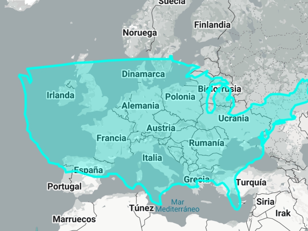
And it’s crazy to think that Europe would fit into North America many times. I would like to see the NA city subways/trains added then compare them to Asia

???
North America is more than the continental USA.
Canadian passenger service isn’t much better than the US. Mexico isn’t too bad.
Train companies have to pay property tax on the lines
And the trucking unions fight against using rail because “jobs”
Those are the two main reasons rail sucks in Canada
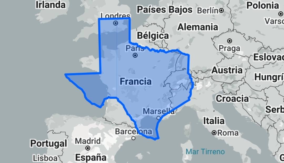
Most of the euro side of that map, fits into texas alone. The USA has shit rails but acting like Europe has even half the distance that’s needed to cover the usa like it looks in this map is dishonest.
I miss spoke, but the size of the EU vs the usa is no where near the same.
https://www.newgeography.com/content/005313-which-countries-would-fit-inside-texas
EU 1.7m sq miles USA 3.8m sq miles
Not even in the same ballpark.
What the fuck are you on about

Just France covers most of Texas.

No, you don’t get to add russia into that. That area is 1.7m sq miles while the USA is 3.8m sq miles.
https://en.m.wikipedia.org/wiki/Geography_of_the_United_States
You don’t get to super impose the usa as a map image to this image and go “see told you”
You don’t get to spout bullshit like “Most of the euro side of that map, fits into texas alone” then try and defend yourself using area measurements that are completely irrelevant to the point I was refuting.
Besides, the map above doesn’t show a map of the EU’s rails. That’s a political grouping. Better try the geography of Europe (3.9m sq mi) if we’re going that route. Of course then you’d rightfully point out that’s a map of North America not the US.
In any case area is not very relevant. It’s very obvious that US rail is lacking far behind. That’s understandable in much less sparsely populated areas the US has. But look at the highly populous northeast corridor. Hardly compares to EU rails.
Texas is about the size of France, with The Netherlands tacked on. Europe would fit east of the Mississippi, not in the second largest state.
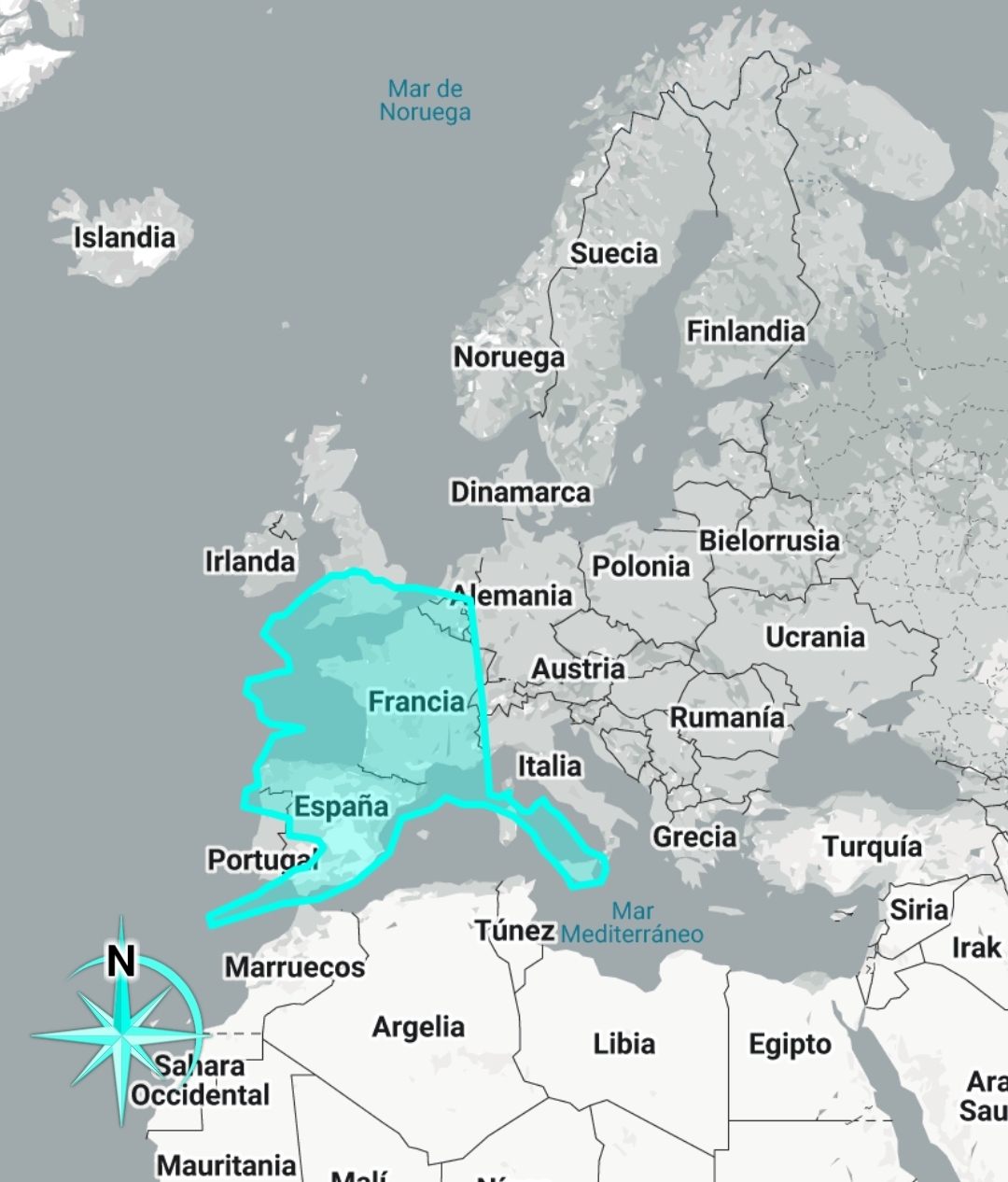
Alaska, however, is bigger than Europe
Alaska is huge sure but definitely NOT larger than Europe

Alaska is 1 477 300 km2
Europe is 10 180 000 km²
you need to familiarize yourself with how Map projections distort the shape and size of land masses, because that’s the only way i can imagine you got this idea.
it’s not even close, Alaska is way smaller than Europe. go look to some actual statistics. with all of its landmass combined the United States is 0.98x the size of Europe. it’s smaller, but barely. they are nearly exactly the same size if you made them both into a circle.
If you added in russia…russia doesn’t count because 95% of it is baren wasteland with no rails.
Alaska is smaller then Europe by quite a bit.
Where we’re going, we won’t need roads!
This needs to be higher. The US has the most rail in the world, at over 224,000 miles. Europe, by comparison, has 94,000 miles. That’s one country having more rail than the total of a whole continent.
The map down in the meme appears to only be Amtrak.


